 |
| Click on photo to enlarge to view |
Soil is one of our most basic natural resources, but we rarely see more than its surface - and even that is usually hidden by pavement, crops, or trees.
To most people, the soils of Ohio all look and feel pretty much the same. However, farmers and builders know that soils differ within most fields and city blocks. Soils are also different from region to region across the state.
The vast majority of soils are composed mostly of mineral material - small bits of decomposed rock. But soil is more than a collection of mineral particles. Pore spaces between these particles contain air and water required by the plants and animals living in the soil.
Most soils also contain organic matter (from plants and animals), which darkens the uppermost layer of soil and affects the way in which soil particles hold together.
While many people think of soil as "dead", soil literally teems with life, from roots, insects and worms to molds, fungi and bacteria that number in the billions. Soils form slowly over time as the mineral particles from geologic or "parent" materials are changed by the effects of weather, plants, and animals in a landscape setting. Soils vary between regions largely because there are so many different landscapes and types of parent material across the state.
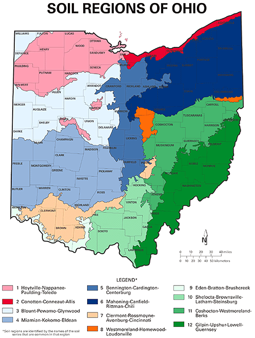
Over the past century, soil scientists have identified more than 400 different kinds of soils, called series, in Ohio.
What Are Soil Series?
Scientists have classified the world's soils according to a six-level system, much like plants and animals are classified. The system follows a "most general to most specific" arrangement: order-suborder-great group-subgroup-family-series. Soil "series" are at the most specific level in the system. A soil series corresponds to the "species" level in the classification system for plants and animals. Soil series are commonly named for cities or towns near where the soils were first studied. Soils classified in the same series have horizons (or layers) that are similar in composition, thickness, and arrangement.
Soils in the Miamian series, for example, are well drained. They typically have a very dark grayish brown to brown silt loam or loam topsoil layer ("A horizon") 5 to 10 inches thick. They commonly have a brown or yellowish brown subsoil layer ("B horizon"), 8 to 35 inches thick, with a higher clay content than the A horizon. Below the subsoil, soils in the Miamian series have a brown to light olive brown substratum ("C horizon") that is slightly or moderately alkaline and has a lower clay content than the B horizon.
How Were the Soils Identified?
Soil surveys in Ohio have been conducted on a county by county basis by soil scientists with shovels, augers, and other tools since 1899. The Soil Survey of Montgomery County, Ohio, published in 1900, recognized only one soil series (Miami). A statewide soil survey was conducted in 1912, and 24 different soil series were recognized.
By 1992, soil surveys had been completed in every county in the state. Modern soil surveys must be much more detailed than the early surveys in order to provide the information needed to manage Ohio's soil resources. Today, soil maps for Montgomery County show 38 different soil series, delineated in areas as small as five acres. More than one hundred soil series are recognized on detailed soil maps in the area identified as Miami in the 1912 survey. (The most common soil series in this part of the state, corresponding to Soil Regions 3 and 4, are Miamian and Blount.)
How Was The Map Prepared?
In the late 1980s, information on thousands of detailed Ohio soil maps was analyzed for the Natural Resources Conservation Service to develop a statewide geographic soil data base known as STATSGO. This data base identified 166 different groupings, or "associations," of soil series that are common in areas that could be mapped at a scale of 1:250,000. The Soil Regions of Ohio map was prepared in 1996 by combining these associations into twelve regions at a scale of 1:2,500,000, with the assistance of ODNR's Division of Real Estate and Land Management's geographic information system (GIS).
No comments:
Post a Comment